Wind chill tomorrow by zip code: how to plan for dangerous cold
Wind chill tomorrow by zip code tells you when cold air and wind will combine into a more dangerous exposure window than the thermometer alone suggests. The biggest planning gain usually comes from shortening outdoor waiting time before sunrise, sealing clothing gaps, and watching for the current cold-alert terminology that replaced older wind chill advisories.
Wind chill tomorrow by zip code matters because a 5 F morning with a stiff wind behaves very differently than the same air temperature in calm conditions. If you already use our weather tomorrow by hour, what to wear tomorrow weather guide, and winter car emergency kit checklist, this page adds the missing cold-exposure layer so school, work, walking, and travel plans are built around actual skin-exposure risk instead of the air temperature alone.

How do you check wind chill tomorrow by zip code without misreading it?
The biggest mistake is treating wind chill like a single trivia number instead of a time-block decision tool. Start by finding the coldest hour before sunrise, then compare it with the windiest hour during your outdoor obligations. In many places, those two hours are not the same. That matters because school arrival, outdoor work setup, transit waits, and pet walks often happen before the daily temperature begins to recover, while exposed afternoon errands can still feel harsher if winds stay elevated.
The National Weather Service uses the wind chill temperature index when the air temperature is 50 F or lower and wind speeds are above 3 mph. That formula estimates how fast exposed skin loses heat, which is why it is more operationally useful than the air temperature alone for planning when skin coverage, gloves, and time outdoors need to change. If tomorrow has light wind, the difference between air temperature and wind chill may be small. If tomorrow has 15 to 25 mph wind, the gap can become large enough to change the whole morning routine.
Use the hourly forecast in sequence. First, find the coldest wind chill block. Second, map your fixed commitments into it. Third, move or tighten everything flexible. This is the same planning logic that makes our best time to be outside tomorrow tool useful, but cold weather needs a more defensive threshold because the body loses dexterity and judgment faster in wind than many people expect.
| Wind chill band | Operational meaning | Best move for tomorrow |
|---|---|---|
| 20 F to 0 F | Cold is uncomfortable, but short exposure is usually manageable with normal winter clothing. | Add gloves, a hat, and wind-resistant outerwear before the commute or walk. |
| 0 F to -19 F | Cold stress rises fast on exposed skin, especially on bus stops, open parking lots, and athletic sidelines. | Shorten outdoor waiting time, cover all skin, and keep spare layers available. |
| -20 F to -34 F | Frostbite risk becomes serious during ordinary routines when exposure stretches beyond a few minutes. | Treat outdoor time as a controlled task, not a casual errand, and move optional activity indoors. |
| -35 F and lower | Dangerous cold can overwhelm weak clothing systems quickly and disrupt school, work, and travel decisions. | Avoid prolonged exposure, reduce travel, and check for local cold-hazard alerts before leaving. |
What makes wind chill different from air temperature or a generic feels-like reading?
Wind chill is a specific cold-weather safety index, not just a casual way of saying the day feels bad. It estimates the cooling effect of wind on exposed skin, which is why it is tied to temperature and wind speed thresholds. By contrast, an app's generic "feels like" label may point to heat index in summer, wind chill in winter, or a simplified display rule that does not tell you exactly which formula is underneath. That is good enough for quick scanning, but it is weaker for decisions that depend on exposure timing and frostbite risk.
This distinction matters because cold-weather planning is mostly about exposure control. The air may be 8 F, which sounds survivable for a short walk. If the wind chill is minus 12 F, that same walk now asks more of your gloves, face coverage, and route timing. People get into trouble when they dress for the thermometer but wait outdoors according to the wind chill. If tomorrow includes open parking lots, bus stops, sports sidelines, or elevated walkways, the wind-driven heat loss often matters more than the air temperature headline.
The practical rule is simple: in cold weather, trust wind chill for skin-exposure planning and trust the thermometer for mechanical questions like whether roads may refreeze or whether pipes are at risk. They answer different questions. Use both, but do not let one stand in for the other.
What wind chill is dangerous to be outside, and when does frostbite risk jump?
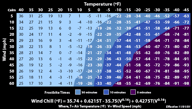
Dangerous is not a single number because duration, clothing, moisture, age, and activity matter, but the NWS wind chill chart gives one of the clearest decision anchors available. The chart shows frostbite timing tightening rapidly as wind chill falls through the negative teens and lower. That is the change many households underestimate. A cold commute can move from annoying to medically relevant with only a modest increase in wind speed if the base temperature is already low.
Operationally, the minus 18 F area of the chart is where many people should stop treating outdoor waiting as routine. Near minus 32 F, the chart shows frostbite can happen in around 10 minutes. Near minus 48 F, the chart estimates around 5 minutes. Those are not abstract survival stories; they are school pickup lines, snow shoveling breaks, transit platform waits, and roadside incidents. Wet skin, thin gloves, or exposed cheeks can make the situation worse than the chart suggests.
This is why the best planning move is usually not to search for a perfect coat rating. It is to reduce exposure duration first, then upgrade the clothing system second. Compressing an outdoor block from 20 minutes to 5 minutes can matter more than adding one extra mid-layer while leaving a long wait unchanged.
How long does it take to get frostbite at certain wind chill values?
The chart-based answer is not meant to scare people into staying inside for the entire winter. It is meant to help you stop making unmeasured exposure decisions. When tomorrow's wind chill drops into a frostbite-timing zone, you should treat outdoor time like a planned task with a clear start, finish, and warm recovery point. That is different from casually letting a bus stop wait or a school arrival line stretch longer than expected.
Parents, coaches, managers, and commuters should think in margins. If the chart shows 30 minutes to frostbite and your real exposure block could reach 20 minutes because of delays, you do not have a comfortable safety cushion. If the chart shows 10 minutes and the group has mixed clothing quality or younger children, the practical margin is even smaller. Build the plan around the weakest clothing system and the slowest-moving person in the group, not the hardiest adult.
| Approximate wind chill | Chart-based frostbite timing | Why it changes tomorrow's plan |
|---|---|---|
| -18 F | Around 30 minutes | This is the point where waiting outdoors starts to behave like a real exposure problem rather than a comfort issue. |
| -32 F | Around 10 minutes | School drop-offs, outdoor work setup, and short roadside stops can become medically relevant exposures. |
| -48 F | Around 5 minutes | Small delays matter, and any skin left uncovered becomes a critical weak point in the clothing system. |
In dangerous cold, shortening exposure is often the fastest and most reliable control because it works even when clothing quality, wind direction, and delays do not.
What should schools, commuters, and outdoor workers change when wind chill is low tomorrow?
The correct response is rarely "cancel everything" or "do nothing." Most of the time, it is a threshold adjustment. Schools can shift waiting indoors, compress arrival transitions, or reinforce face and hand coverage rules for bus riders. Commuters can warm the vehicle first when safe, reduce time spent scraping or loading outside, and keep backup gloves in the car instead of assuming one pair is enough. Outdoor crews can front-load indoor prep, rotate higher-exposure tasks, and stage warm-up intervals before discomfort starts to hide declining dexterity.
The planning win comes from matching the schedule to the coldest block, not just adding more gear. For example, if the worst wind chill lasts from 6 AM to 9 AM and eases by late morning, moving one practice block or one exterior task package later can reduce exposure without cutting the whole day. This timing logic works especially well when you pair wind chill with our hourly forecast and the broader cold-alert context from our freeze watch vs warning guide.
School closure and work-delay thresholds also vary widely, which is why people often search for school wind chill threshold values and still find mixed answers. The better habit is to watch for your local district or employer decision rules and compare them with tomorrow's hour-by-hour wind chill window instead of assuming a national number controls every place.
What should change at 10 F, 0 F, and negative wind chill tomorrow?
A threshold table beats vague advice because cold-weather compliance falls apart when people rely on morning judgment alone. The best operating plan assigns a default action to each range before the day starts. That way the household, team, or crew does not debate every coat, glove, or waiting decision under time pressure.
| Wind chill threshold | Decision headline | Clothing move | Schedule move |
|---|---|---|---|
| Above 10 F | Normal winter planning | Use gloves, hat, and closed footwear if you will be outside for more than a few minutes. | You usually do not need major schedule changes unless precipitation or ice adds another hazard. |
| 10 F to 0 F | Start tightening the routine | Add a wind-resistant shell and cover ears and fingers before leaving home. | Cut standing or waiting time and keep a warmer fallback plan for early-morning obligations. |
| 0 F to -19 F | Treat exposure as a managed risk | Seal neck, wrists, and face gaps because small openings matter in wind. | Move optional outdoor time, warm the car first if safe, and double-check children and older adults. |
| -20 F and lower | Use a protective operating plan | Layer for full coverage, carry backup gloves, and assume exposed skin is unacceptable. | Avoid long waits, shorten trips, and verify whether alerts or closures have changed the day. |
This kind of pre-committed table is what turns weather awareness into actual risk reduction. It also helps bridge cold-weather pages on this site: once wind chill drops into the more disruptive ranges, our winter car emergency kit checklist becomes less of a generic preparedness article and more of a same-day travel tool.
What happened to wind chill advisory alerts, and what terms should you watch now?
One of the biggest sources of confusion in current cold-weather searches is that alert names changed. Beginning October 1, 2024, the National Weather Service rolled out cold-hazard simplification changes in many regions. Wind chill advisory was replaced by cold weather advisory, and wind chill warning was replaced by extreme cold warning. That does not mean wind chill stopped mattering. It means the public-facing headlines were simplified while the product text can still describe whether the danger comes from low temperatures, wind chill, or both.
This matters because people still search for older terms and assume the alert disappeared. In reality, the operational question is the same: how cold will exposed skin effectively behave, and what action window does that create? If tomorrow looks severe, do not stop at the headline name. Read the actual product text, the timing, and the local office messaging. The headline changed; the exposure physics did not.
For households, the easiest adjustment is to treat cold weather advisory as the modern equivalent of "pay attention to tomorrow morning's exposure window" and extreme cold warning as the stronger act-now signal for dangerous cold. That same discipline applies across other hazards too, which is why our watch, warning, and advisory explainer remains useful alongside this colder-weather page.

What should a nightly wind chill planning workflow look like?
1. Find the coldest wind chill block first
Do not start with the daily low. Start with the lowest hourly wind chill and note how long the worst block lasts.
2. Lock in fixed outdoor commitments
School arrival, transit, dog walks, and outdoor job tasks are your immovable blocks. Once those are placed, move everything flexible around them.
3. Stage the clothing system before bed
Put gloves, face covering, and the wind-resistant outer layer in one place. In extreme cold, logistics failures cause more underdressing than lack of knowledge.
4. Cross-check travel and breakdown risk
Review the route, gas level, charger, and emergency kit if the coldest block overlaps travel. A short breakdown in dangerous wind chill can matter more than a long drive inside a warm car.
5. Recheck alerts in the morning
Cold-weather headlines and wind forecasts can tighten overnight. A two-minute recheck can save you from treating an extreme cold warning like an ordinary cold commute.
| Tomorrow scenario | Key signal | Best move | Why it works |
|---|---|---|---|
| School morning | Worst wind chill lines up with bus-stop and door-opening times | Shift waiting indoors when possible, add face coverage, and compress drop-off time outdoors | Children accumulate exposure while standing still, which removes the body heat benefit that comes from movement. |
| Outdoor work crew | Subzero wind chill lasts through the first half of the shift | Front-load indoor prep, rotate outdoor tasks, and stage warm-up breaks by schedule instead of by feel | Cold judgment gets weaker under repeated exposure, so fixed operating rules beat informal judgment. |
| Commute or transit | Cold peak overlaps platform waits, parking-lot walks, or highway incident risk | Add windproof layers, charge the phone, and carry gloves even for short drives | Many cold-weather problems happen in the transition between vehicle and destination, not during the drive itself. |
| Practice or recreation | Wind chills stay much lower than the air temperature suggests | Shorten the outdoor block or move it later if wind relaxes after sunrise | A one-hour timing shift can change the exposure category without canceling the whole plan. |
FAQ: wind chill tomorrow by zip code
How do I check wind chill tomorrow by zip code?
Start with the hourly forecast for your ZIP code, then compare the air temperature and forecast wind speed during the coldest block before sunrise and the windiest daytime block. That timing view is more useful than a single low number because wind chill risk depends on both temperature and sustained wind.
What wind chill is dangerous to be outside?
Danger rises as wind chill drops below zero, and the risk becomes much more serious when values fall into the negative teens and lower. The National Weather Service wind chill chart shows frostbite times tightening quickly as wind chill falls through about minus 18 F and especially below minus 32 F.
Is wind chill the same as feels like temperature?
Wind chill is a specific cold-weather formula used when air temperature is 50 F or lower and wind speed is above 3 mph. "Feels like" is broader app language that may also cover heat index or other presentation logic, so it is not always the same calculation.
How long does it take to get frostbite at certain wind chill values?
The NWS wind chill chart estimates frostbite can occur in around 30 minutes at about minus 18 F wind chill and around 10 minutes near minus 32 F. Exposure time, wet skin, clothing gaps, and individual health factors can make real-world risk worse than the chart implies.
What happened to wind chill advisory alerts?
Beginning October 1, 2024, the National Weather Service simplified cold-hazard alerts in many areas by replacing wind chill advisory with cold weather advisory and wind chill warning with extreme cold warning. Offices can still reference wind chill values in the product text, but the public-facing headline names changed.
Authoritative references
For official wind chill interpretation and cold-safety guidance, review the National Weather Service wind chill chart, the NWS cold hazard simplification update, CDC winter weather safety guidance, and Ready.gov winter weather guidance. These sources cover how wind chill is calculated, how frostbite timing is communicated, and what household and travel actions matter most when tomorrow's cold becomes dangerous.